Wednesday 26 June 2019

Walking in the Footsteps

Im currently nursing an injury which I didn't want to agitate by fishing so instead I decided to go walking to a place I always said I would visit so no excuses, a 0430hrs alarm I was up and away on Sunday. 
The reason for such an early rise was that I wanted the place to myself as its a popular walk and to take my time & get some good photographs.

Arriving in Gunnerside, I got the walking boots on and headed for the hills.


This was the place I was heading for, Blakethwaite Dams, 3.5 miles up in the Yorkshire Dales with a elevation just under 1400ft from the car park.

Over 200 years old and built to control the water for the Lead mining industry below, it has stood the test of time well.


This was the first view I got of the dams, one of which has now been destroyed but the 2nd one is still standing strong as you can see from the two opening pictures.


Heading up the Gill to the Dams you weave your way through a thriving but very dangerous industry from the past, Lead Mining. A lot of building still preserved today to give a very small-insight to the work that went on all those years ago, a tough job in a tough place with very tough conditions to endure.


The view from the smelt mill down the Gill towards the Bunting Mine


The view back to the smelt mill looking up towards the dams


Today a part of the history of the area and mixed in amongst our industrial past is small snippets of elegant beauty such as these waterfalls.


Heading down the Gill to the Bunting Mine.


The 8 mile round about walk contained lots of interesting photographs, too many to put into one post but if you are ever in this neck of the woods and have a few hours to spare then I highly recommend visiting Gunnerside Gill.


And with views like this is does the soul good.

Monday 17 June 2019

Goals & Coincidences!

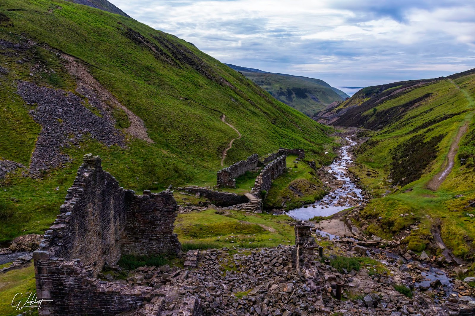
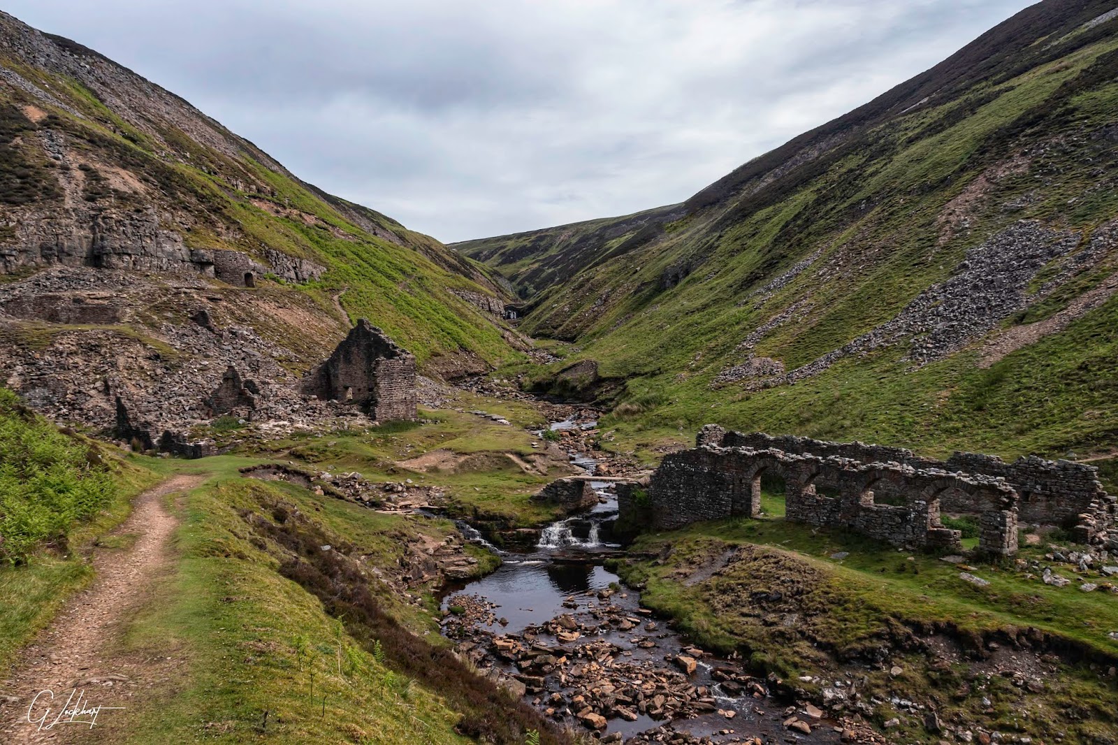
Well another weekend of no fishing due to mother nature giving it her best with the rain, so Plan B came into fruition although I knew it was going to be a long & hurtful slog which I can now confirm it was with the muscle aches & pains I have whilst sat writing this entry. 

The last few weeks I've been researching waterfalls in the dales & I stumbled across 2 which have very limited information or photographs of, one of those photographs was taken in 1988 (31 years ago) so with this in mind I set off yesterday with 3 goals in mind.

Goal One.

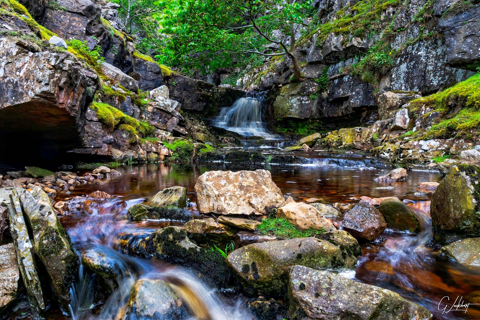
To locate & photograph Birk Gill Waterfall, no online information found & a single winter photograph taken back in 1988 to go on.

I have now found out why the above applied, getting to this waterfall is definitely not for the sick, lame or lazy! In places there was sheer rock faces which I had to constantly avoid just to get up the beck to the waterfall as there was no real places to gain access so had to walk up the course of the beck itself.


Heading up the beck looking back wards with the sheer rock face on the right side.


The first glimpse I got of the waterfall.


Birk Gill waterfall can now officially be seen online after 31 years of no photographs.


After the trek up it was time to head back downstream and a total change of scenery and new challenges, walking through knee deep heather with no clear paths for over 3.5 miles which was definitely energy sapping to my legs, the views were good though!


Goal Two

Find & locate the 2nd forgotten waterfall, Deep Gill Waterfall.  I managed again to find one photograph of this dated back in 2010 but nothing since & it has now got a plantation all around it.  The amount of undergrowth I had to plough through just to find it was like going back to Jungle training & I have more nettle stings and bruises on my legs than I care to admit, but perseverance paid of in the end & after almost 40 minutes of searching I found it.


I had achieved 2 of my goals & to be honest I should have quit as I was totally done in physically & I had to hike back to the car back across the heather but my 3rd goal was on route back to where I had left the car otherwise I would have left it for another day.


As I lay on some dry grass in the corner of the plantation in the sun grabbing a rest before setting off on the Hike back I was joined by a soldier beetle which I though was rather funny, an ex soldier & a soldier beetle sharing the same patch of grass.


A short break to gather my breath & I was back on the trail so to speak, except there wasnt one it was break your own through the heather, The amount of Curlew, Lapwings & Oyster catchers was astonishing, I estimate well over 100 of each type I saw on the moors on my crossing back over.

Goal Three

To find & pay my respects at  the remains / cairn  of a WW2 Halifax Bomber crash where all crew perished. I knew it was in the rough area of the crags I had passed on the south eastern side of the moor. The crags were easy to find but I cannot say the same for the small cairn in all the deep heather that was covering the area.


I sat down on top of a large slab of stone to take a breath where I found this small lichen and only found out after I carried out an internet search today that its called Cladonia Cristatella otherwise known as British Soldier Lichen! 

Two rest stops & two things in common with my surroundings, coincidence or what ?


After a further search of the area I stumbled across the small cairn & recognised it from the photographs I had seen online when I was researching the area.


Old parts of the Halifax Bomber JB926 gathered around the cairn


This is all that remains at the crash site where a complete bomber crew lost their lives on the night of  23/24th November 1943. For the full story of why it crashed please read the link.


After a moment of silence to pay my respects to these brave men I headed back down the moor in the direction of the car, tired but very relieved that I had achieved all the goals I had set out to do, especially the last one which Im glad that I found the energy to complete. RESPECT to these Men, NEVER FORGET.


Thursday 13 June 2019

Waterfall Bonanza

Last weekend we were washed out again on the rivers with storm Miguel hitting the Dales and precipitating so much the rivers were up over 1.5m.

Not one for staying in I opted to head further up the Dales with camera in hand and one thing that would look good would be the waterfalls.

A quick map recce found that there were a large amount of waterfalls located around the village of Keld high up in Swaledale, so setting off at 0630hrs I headed off with camera & walking boots.

The views up in swaledale are worldwide renowned for the amount of stone barns that the dale has.


Just a small sample of the barns from the roadside and every barn has a story to it which is kept alive by the local tourist information's which I find fascinating how they used to live when life was so much less complicated than today.


Parking the car and paying my £2 in an honesty box for all day safe parking I slipped on my walking boots, rucksack over my shoulder and off I headed on my pre planned route, the first waterfall being Kisdon Force.

( Taking lots of photographs, I will keep the shots on here to single ones of the entire falls )


Just as I had expected in full force and moving some amount of water through it per second.


Photographs done, kit packed away I headed back along the Pennine way for my next port of call, another waterfall called East Gill, not as large as it was located on one of the feeder burns supplying the main river but just as pretty.


At this point I still had not seen a single soul, I had all this to myself without any other person bothering me.

Onward & upwards now to a place I have been meaning to visit for many years as the panoramic views are spectacular as I have seen many photographs from others and always vowed I would get up there one day myself, and I wasnt disappointed.


The view on the way up was quite spectacular in itself, I simply cant comprehend how these folk built these stone farms & mile upon mile of dry stone walls all those years ago, what a hard and simple life it must have been.


The walk up was well worth the wait as Im sure you will agree.


Crackpot hall looking down Swaledale with the river Swale down below.  With the clouds & light changing constantly I sat there for over an hour absorbing the different moods that mother nature was throwing at me.


It was still onward & upwards to Swinner Gill an old lead mine high above here for my next waterfall.


The views behind me as I climbed higher just as spectacular.


The Swinner Gill waterfall being in 2 parts, the upper part.


And the bottom part.


Im always amazed at how hard our predecessors worked to make ends meat and this far up an old lead mine workings, how hard must it have been up here in all weathers scraping out a meagre living, lead was first extracted up here in the 1740s, and between 1751 - 1756, 370 tonnes had been removed by hand and processed, & our generation think we have it hard! 


The view up to the mine


The buildings around the mine site.

Leaving the hills I descended back down towards the Swale and the numerous waterfalls in the area.


Currack Force


Wain Wath


Rainby Force


Hoggarth's Leap


And finally the smallest of them all but nevertheless just as pretty.


It might not have the thrills of catching a wild trout or grayling on fly but it gave me just as much thrills and spills in the magnificent views, and the short final walk back to the car for a sit down and a chill before the drive home was just as good as the rest of the day.

Monday 3 June 2019

Not quite equal amounts....

Yesterday I had my day planned out in advance, a friend had told me of a waterfall up a feeder beck higher up the Dale that was worth the walk for some photographs so seeing as I was heading that way I would devote a couple of hours to the waterfall and then spend the rest of the day fishing.....except it didn't quite turn out as intended!

I arrived at the village and parked the car getting there early to avoid the walkers as I knew the car parking is very limited and that at least I could have the waterfall to myself for some photographs without having to worry about others around me. The walk to the waterfall was a nice gentle slope upwards for about a mile, nothing too strenuous and I found it very easily, the rocks with the morning rain were like sheets of ice, so great care was needed when setting up my tripod & gear.


With recent rains & the beck having a good flow of water on it made for good results as you can see from the first photograph.


I was just about to collapse everything & head back to the car when this couple appeared  & we got chatting, they informed me that there were further waterfalls higher up the ravine a total ascent of 600ft but were definitely worth the climb to the very top falls. My photography head took over and my fishing head got parked for slightly longer than I had anticipated, so off I set in the direction they had indicated.

The next set of falls I came to were smaller in comparison to the ones I had set out to photograph, but still quite nice in scenic terms.


Continuing to head upwards I came to the next set, the prettiest of them in my personal opinion.


Leaving these falls behind the small track got steeper and muddier and with only a set of walking shoes on I was getting dirtier by the minute, but I was anticipating that it would be worth it,  so onward & upwards through the trees and the mud pools to finally I could hear the falls but they were still obscured by the trees, heading along the side of the bed, slipping & sliding in the mud I came to a spot where I could finally get to see the falls & sure enough they were worth the scrambling through the undergrowth and fallen trees.


The beck had revealed its secrets to me and I was glad that I had made the effort to see them, albeit it my foot attire wasnt that appropriate for the conditions, & due to this I had missed out at least another 2 or 3 smaller waterfalls on route to the top but these can be re visited at a later time when Im more appropriately dressed. On the descent back to the car I stopped along the way for some macro shots of the flowers which covered the woodland floor.


Tiny forget me not


and speedwell's


By the time I had headed back to the car and got my camera gear away it was well into the afternoon and I was famished so needed to take a break for something to eat.

The short drive from my current location to my chosen fishing grounds took around 20 minutes but I had bitten deep into my fishing time as I had promised the wife I would be home at a certain time.

Looking over the bridge I could see surface movement of fish rising to flies so that was it no doubt I was fishing even if only for an hour.

The first thing to be spotted was what the fish were rising too.


Blue winged olives but I could be mistaken as a few seem similar in appearance.


So hunting through my dry fly box for a suitable imitation I started my  hash dash fishing session.


It didn't take too long until the first fish albeit a splashy rise took my artificial.


The next fish lead me a merry dance before my leader got caught up in some overhanging willows and yep you guessed fish gone, the air turned slightly blue for a few short seconds! retrieving the remainder of the cast another fly and another fish covered.


Smaller but just as beautiful and totally wild, I couldn't ask for anything more.


another small fish covered and another small fish hooked before it was time to leave the river & head home.


Not quite the time split I had planned for my day but it was worth the extra time in the morning for the photographs